I wanted to create a graph of some data that has 4 dimensions, so I did it in Google Earth.

nice off-label use of GE. i wonder what else people would like to do with this widely deployed 3d engine?
Sapere Aude
Tag: visualization
I wanted to create a graph of some data that has 4 dimensions, so I did it in Google Earth.
nice off-label use of GE. i wonder what else people would like to do with this widely deployed 3d engine?
 this looks sweet. now we need a protein visualization app for the wii. i can already picture the weird contortions people will be doing in their living rooms to navigate dna and such. 50k new folding @ home users. millions are needed, though. otoh, those 50k signed up in 2 weeks and are already providing 330 TFLOPS, compared to the 276 TFLOPS of the existing 2m desktop clients.
nice powers of 10 style app, but why not go to the planck scale?
I’ve just added preliminary 9-block IP identification feature to Daily, my blog server to enhance commenter identity beyond name and website. Basically, what I am doing is using a privacy protecting derivative of each commenter’s IP address to build a 9-block image and displaying it next the commenter’s name.
creates a unique graphic per ip. people get excited about the look of their ip 🙂
lets you investigate the actions and reactions of Enron’s senior management team as the noose began to tighten.
heat maps for reviews, but the drill down needs to be there
nice visualization of all books talking about a particular region.
Shining light on the biggest waste of taxpayer money ever.
2007-04-04: In celebration of the new annotated Google Maps, I have created 2 maps that show your taxes at work:
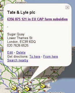

The top recipient of EU CAP farm subsidies in the UK got $700M, the top recipient of USDA farm subsidies in the US got $541M.
2007-08-28: Nice complement to my pork mapshop maps.
2007-11-08: This is why I make farm subsidy maps 🙂
eliminating farm subsidies in the first world and liberalizing trade would produce annual benefits of $2.4t, with 50% of that accruing to the third world.
2008-06-10: Nice! They now have their own maps, starting with Sweden. Fight the pork.
There should be a Google Earth and a Google Map for the body, where you could rotate and navigate the human body in 3d, and zoom in, but instead of stopping on the surface, the zoom should continue through the skin, so that you could look on all the different layers, organs etc.

